Drew Ludwig · 2 November 2026
Understanding Drainage Patterns to Prevent Erosion Around Elevated Woodland Dwellings
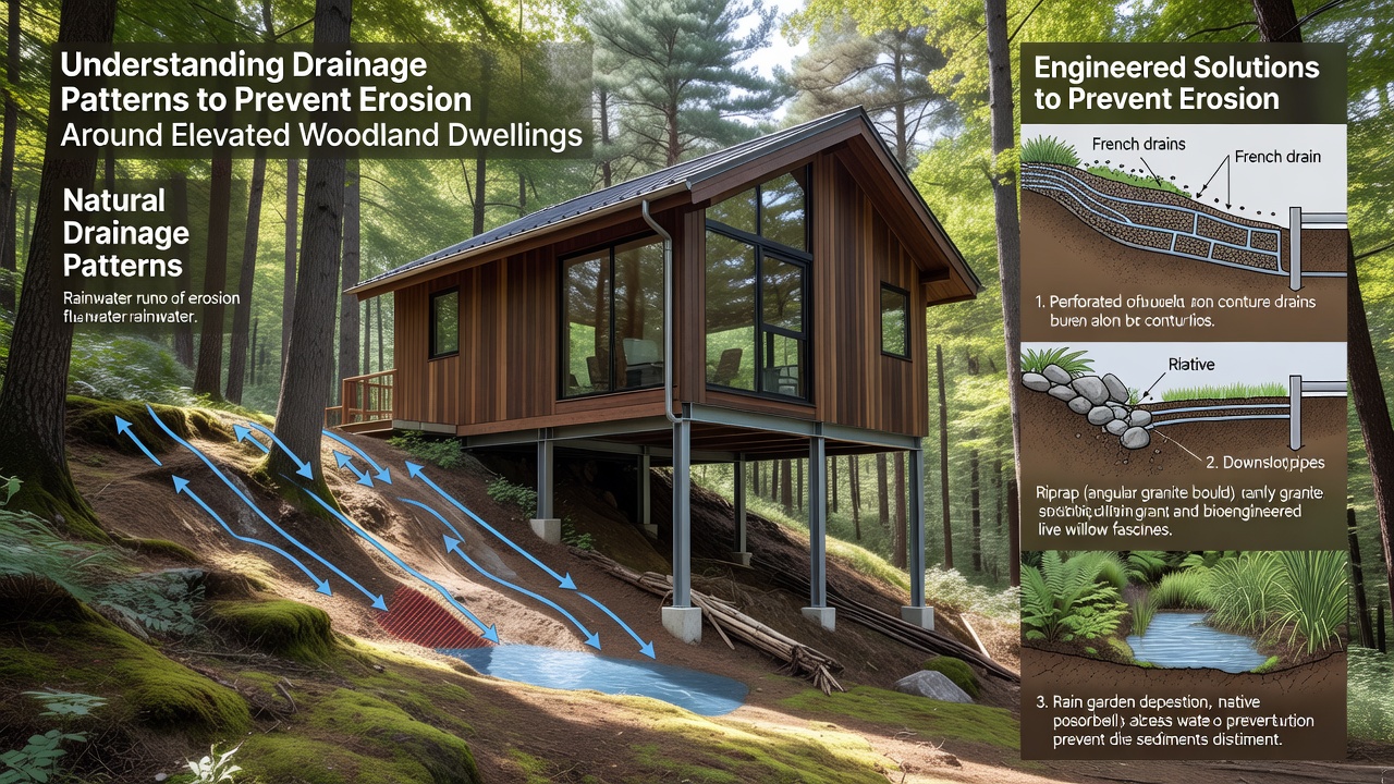
Elevated woodland dwellings sit amid complex terrain where water moves downslope through root systems, leaf litter, and varying soil layers, and observers note that these patterns often concentrate flow into narrow channels during heavy rain events. Researchers have documented how such concentration accelerates soil displacement when structures interrupt natural gradients, which leads to undercutting of foundations and exposure of root networks that previously stabilized slopes.
Formation of Drainage Networks in Forested Uplands
Water follows gravity across uneven forest floors, and dendritic patterns emerge where multiple small rivulets merge into larger streams that carve deeper paths over repeated cycles. Data from long-term monitoring sites show that woodland soils with high organic content absorb initial rainfall but reach saturation thresholds faster on steeper inclines, which forces excess volume to travel along surface routes. In November 2026 the USDA Forest Service published revised mapping protocols that integrate LiDAR surveys with seasonal precipitation records, and those protocols help identify high-risk corridors around existing dwellings before visible erosion begins.
Radial drainage develops around isolated hilltops while parallel patterns appear along consistent contours, and each type interacts differently with building placements. Studies conducted across Appalachian and Pacific Northwest sites indicate that dwellings positioned near convergence points experience greater sediment transport because multiple upslope flows combine their energy at those locations.
Mechanisms Linking Drainage to Soil Loss
Once water gains velocity it detaches particles through splash erosion and then transports them via sheet flow or concentrated rills, and this process intensifies when vegetation cover is reduced during construction or maintenance activities. Evidence collected by Canadian forestry researchers demonstrates that compacted access paths act as artificial channels that redirect water away from its original diffuse pattern, which concentrates force along structure perimeters and accelerates bank failure on downhill sides.
Seasonal freeze-thaw cycles further loosen soil aggregates in temperate zones, and subsequent spring flows exploit those weakened zones to deepen existing incisions. Figures from the Australian Department of Climate Change, Energy, the Environment and Water reveal that properties with inadequate cross-slope diversions lose measurable topsoil volumes each decade, particularly where roof runoff is discharged directly onto unprotected grades.
Assessment Techniques for Site-Specific Patterns
Professionals begin evaluations with topographic analysis that traces flow lines from ridgelines to valley bottoms, and they supplement this with dye tracing or piezometer readings to confirm subsurface movement. Those measurements allow precise placement of interventions that intercept water before it reaches building envelopes. Multiple case studies compiled by university extension programs illustrate how pre-construction mapping reduced post-build erosion rates by directing flows into stable vegetated zones rather than allowing them to pool against retaining walls.
Remote sensing combined with ground-truth verification now provides annual updates on channel migration, and property managers use these datasets to schedule maintenance ahead of predicted high-flow periods.
Intervention Methods Grounded in Observed Flow Behavior
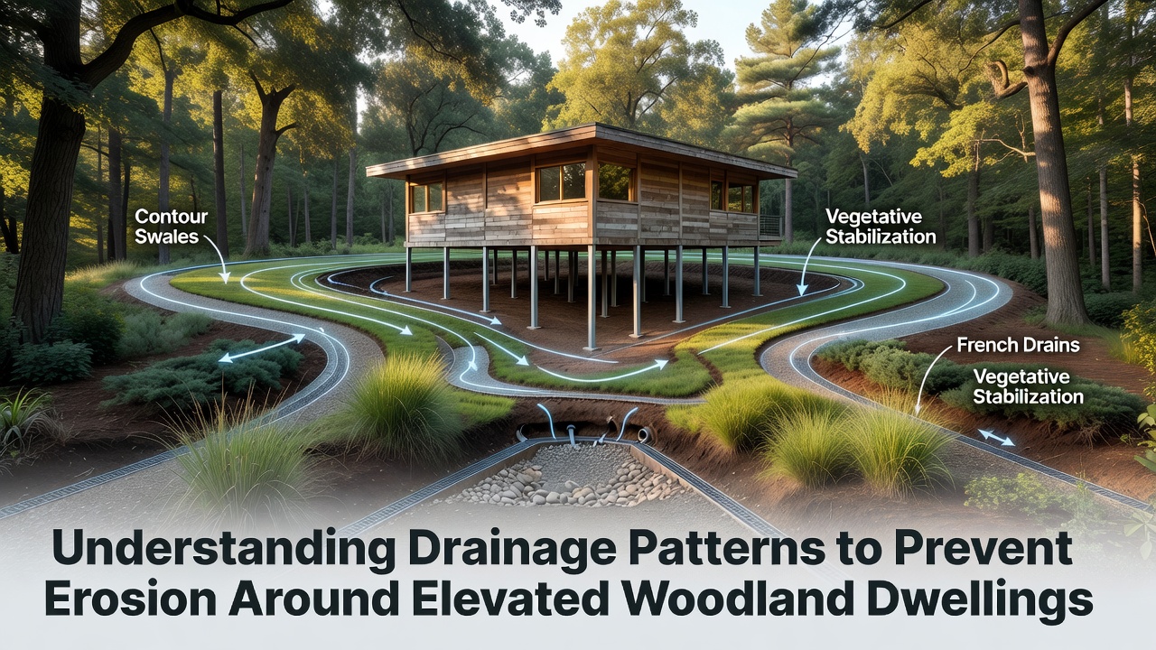
Swales constructed along contour lines slow and spread water across broader areas, which promotes infiltration and reduces peak velocities that drive rill formation. French drains installed at foundation perimeters collect subsurface seepage and convey it to outlets armored with rock aprons that dissipate energy before release onto forest floor. Research indicates that combining these linear features with native plantings creates self-reinforcing buffers because root systems bind soil while canopies intercept rainfall impact.
Check dams placed within existing channels reduce gradient and trap sediment that would otherwise reach downslope dwellings, and periodic removal of accumulated material maintains their function. Data collected from monitored installations show sustained performance when outlets remain free of debris and vegetation is allowed to establish along channel margins.
Regulatory and Monitoring Context
Local ordinances increasingly reference drainage pattern analysis during permitting for elevated woodland sites, and compliance documentation now incorporates modeled flow volumes under projected climate scenarios. Agencies in multiple regions require post-construction verification that installed systems maintain original pattern integrity rather than creating new concentrated discharge points. Observers note that properties adhering to these standards experience fewer corrective interventions over multi-year periods compared with those built without such assessments.
Conclusion
Effective management begins with recognition that woodland drainage operates as an interconnected system where small alterations produce measurable downstream effects, and sustained monitoring combined with appropriately scaled interventions preserves both structural integrity and surrounding soil stability. Updated mapping resources released in late 2026 provide practitioners with improved tools to anticipate and address pattern shifts before they manifest as visible erosion around elevated dwellings.